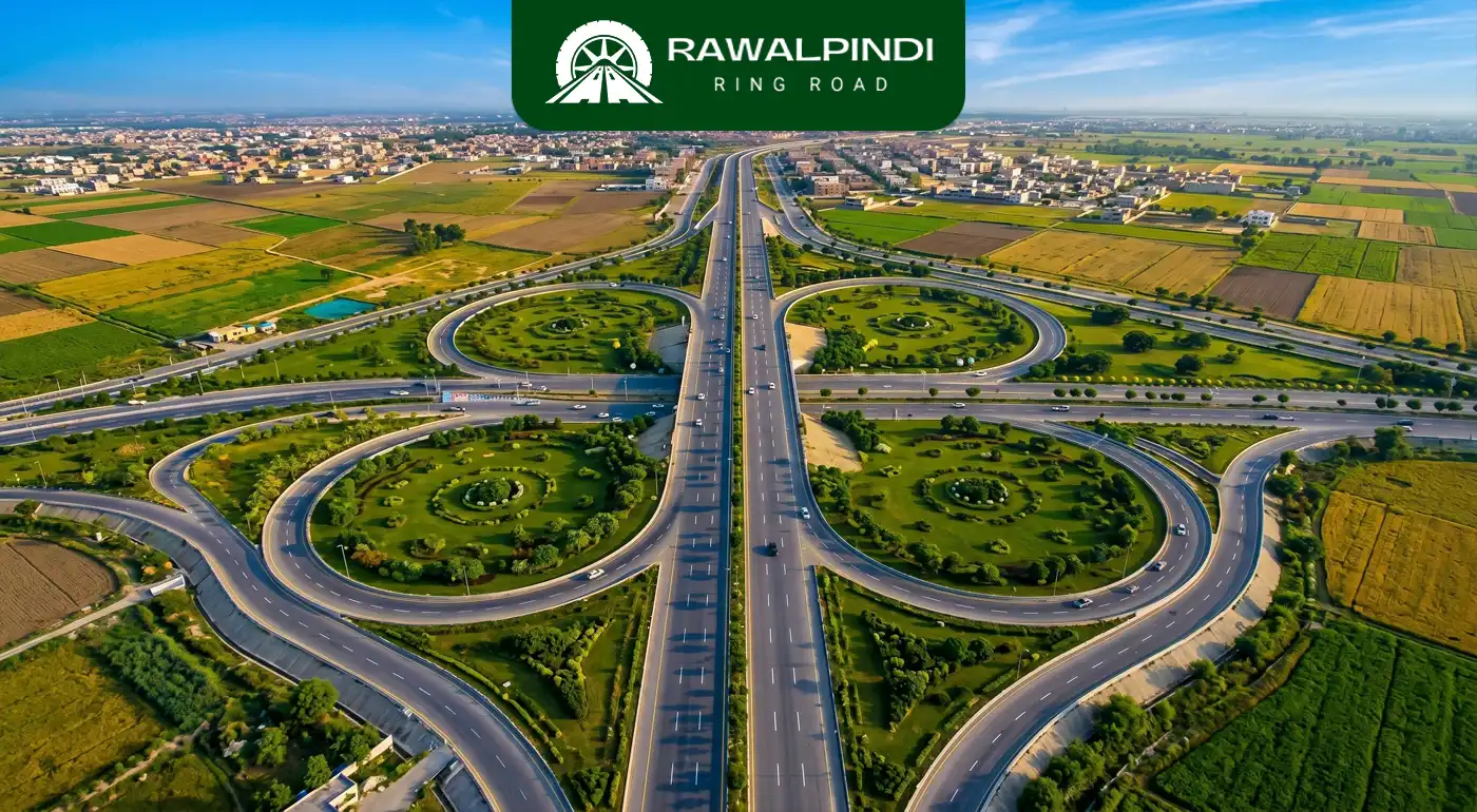
Route and Length
The Rawalpindi Ring Road runs as a single corridor from the Banth interchange on GT Road (N-5) near Rawat, through Chak Beli Khan, Adiala Road, and Chakri Road, terminating at the Thalian interchange close to the M-2 Motorway and the New Islamabad International Airport. Despite its name, the current alignment is a linear bypass rather than a closed loop. It does not circle back to reconnect with itself. An earlier, larger version of the project was designed as a roughly 65–68 km loop connecting back to Islamabad’s planned Margalla Highway, but that version was scrapped after a 2021 corruption inquiry, and the project reverted to a scaled-down, point-to-point route.
- Official name: Rawalpindi Ring Road
- Type: Access-controlled expressway
- Proposed length: 65.3 km
- Approved length: 38.3km
- Start point: Banth interchange on GT Road (N-5), near Rawat
- End point: Thalian interchange near the Lahore–Islamabad Motorway (M-2)
- Lanes: 6 lanes upon full completion
- Design speed: 120 km/h
- Right-of-way (ROW) width: 90 metres
- Executing agency: Rawalpindi Development Authority (RDA)
- Main contractor: Frontier Works Organisation (FWO)
- Foundation stone laid: March 2022
- Construction start: August 2023
Lanes and Design Specifications
- Carriageway: Designed as a 6-lane, dual-carriageway expressway
- Right-of-way: 90 metres wide, allowing for future widening or additional infrastructure
- Design speed: 120 km/h
- Access control: Controlled-access design. Entry and exit are limited to designated interchanges rather than open intersections
- Service roads: Service roads are being built alongside sections of the main corridor
Interchanges
The project includes five planned interchanges:
- Banth Interchange (GT Road / N-5): The eastern starting point near Rawat.Connects the Ring Road to GT Road and traffic heading toward Islamabad’s Faizabad/Murree Road corridor.
- Chak Beli Khan Interchange: Links the Ring Road to Chak Beli Khan Road.
- Adiala Road Interchange: Connects to Adiala Road and provides access to adjoining housing schemes. Located near Adiala Jail.
- Chakri Road Interchange: Connects to Chakri Road, an area with multiple housing societies.
- Thalian Interchange (M-2 Motorway): The western terminus, providing access to the Lahore–Islamabad Motorway (M-2) and onward to the New Islamabad International Airport.
As of mid-2026, the Banth, Chak Beli Khan, Adiala, and Chakri interchanges have been reported as complete or near-complete while Thalian interchange has been deferred to a later phase.
Bridges and Structures
Per RDA documentation, the corridor’s engineering scope includes:
- 2 river bridges, over the Soan River and the Sill River
- 2 railway bridge
- 7 bridges over nullahs and crossroads
- 30 overpasses
- 7 subways/underpasses
- 70 min culverts
Cost History
The project’s budget has been revised multiple times and different figures appear at different points in time:
Period | Reported cost (approx.) | Notes |
Original PC-1 (pre-2021) | Rs 26–33 billion | Based on smaller alignment |
2024 revised PC-1 | Rs 39–44 billion | Cost escalation attributed to inflation and design revisions |
Early 2026 | ~Rs 42 billion (main road) + Rs 5 billion (Thalian) ≈ Rs 47 billion | Thalian interchange redesigned to a wider format |
Mid-2026 | Rs 46.64 billion (excluding Thalian) to Rs 51.4 billion (including Thalian) |
Land Acquisition
- Land acquired for the current alignment is approximately 8,992 kanals
- Cost of land acquisition is approximately Rs 6.7 billion
- Compensation rates offered to landowners/affectees in earlier phases ranged from Rs 69,000 to Rs 350,000 per kanal, depending on location.
- Affected categories cited by residents included cultivated land, homes, schools, and graveyards along the route
Project History and Timeline
- 1991: Project first proposed under Prime Minister Nawaz Sharif. Was not pursued due to political turmoil
- 2010: Discussed with Chinese authorities during Shahbaz Sharif’s visit to China as Punjab Chief Minister
- 2017: Project briefed to the Asian Development Bank for potential financing
- 2018: Fresh PC-1 feasibility study conducted by the Punjab government. Original alignment was approved at roughly 22 km
- 2020: Alignment reportedly changed administratively, expanding the route toward Attock district, eventually reaching a planned length of roughly 65–68 km
- March 2021: Bidding process for the project halted just before the submission deadline amid controversy over the alignment change
- April 2021: Prime Minister Imran Khan ordered a formal inquiry into the alleged route change
- May 2021: Separate inquiries were conducted by NAB and Punjab’s Anti-Corruption Establishment (ACE) against allegations.
- March 2022: Foundation stone laid for the (by-then-revised) project
- September 2023: Construction formally began on the current, scaled-down 38.3–38.6 km alignment
- 2024: Project reported at roughly 29% completion. Revised PC-1 cost estimate increased to address inflation and design changes
- Mid-2025: Project reported at roughly 50% completion, earthwork reported 100% complete
- December 2025: First of several revised completion deadlines set by Punjab CM Maryam Nawaz, later missed
- March–June 2026: Deadline revised multiple times (March 30 → May 30 → mid-June). Reported completion progressed from roughly 70% to 90% (excluding Thalian interchange) over this period
- June 2026 (current status): Main carriageway largely carpeted. Banth, Chak Beli Khan, Adiala, and Chakri interchanges reported complete or near-complete. Thalian interchange deferred to a later phase. Formal inauguration is pending for Chief Minister approval.
Housing Societies and Real Estate Activity Along the Route
Multiple private housing schemes near the route are marketed with reference to Rawalpindi Ring Road proximity. Some get easy access to Chakri interchange and motorway route while others have smooth access to Adyala interchange and hence the main city areas too. RUDN Enclave is one of them.
Direct impact of Rawalpindi Ring Road on RUDN Enclave:
RUDN Enclave is located at 0km from the Rawalpindi Ring Road, and the Adyala Interchange serves as a dedicated entry point into the society. This level of connectivity places RUDN Enclave among the most accessible residential societies near Rawalpindi Ring Road.
For residents and investors, this translates into several long-term benefits:
- Faster and more convenient access to Islamabad, Rawalpindi, and key surrounding areas
- Greater appeal for future homeowners seeking smooth daily commuting
- Increased rental potential driven by demand for well-connected communities
- Stronger prospects for property value appreciation as accessibility continues to improve
- Enhanced commercial activity as businesses and services gravitate toward high-connectivity locations
- Lasting investment value supported by a permanent, large-scale infrastructure project
Planned Future Mega Projects
- Industrial estates: The Punjab Industrial Estates Development and Management Company (PIEDMC) has approved a proposal for industrial zones along the RRR corridor but final approval from the Punjab Assembly is pending. If approved, land would be allotted to industrialists at concessional rates through the Rawalpindi Chamber of Commerce.
- Thalian Interchange expansion: A separate, approximately Rs 4.8–5 billion PC-1 for an upgraded, wider Thalian interchange has been approved, to be built by the National Highway Authority (NHA) in a later phase, including a two-lane motorway link road.
- CPEC linkage: A potential future connection between the RRR and the China–Pakistan Economic Corridor network is also expected though this is not yet a funded or formally planned component.
Conclusion
Taken together, the Rawalpindi Ring road is close to delivering on its core engineering purpose. A 38.3–38.6 km, six-lane, controlled-access corridor connecting GT Road to the M-2 Motorway, built to a 120 km/h design standard with the bridges, and interchanges needed to move traffic around Rawalpindi rather than through it. As of mid-June 2026, the bulk of that infrastructure, Banth, Chak Beli Khan, Adiala, and Chakri interchanges, full carpeting on the main carriageway is complete, with only the Thalian interchange and its motorway link remaining as an unfinished, separately budgeted phase.
For commuters, the practical outcome is still very positive. Shorter travel times between GT Road and the motorway, less heavy-vehicle traffic through central Rawalpindi, and a long-awaited bypass finally nearing operational status.